
More snow is expected in Massachusetts, Rhode Island, and Connecticut, following today’s minor snow event.
The National Weather Service predicts that the area will experience several more inches of snow this weekend, following the expected end of the couple inches of snow/sleet/rain tonight.
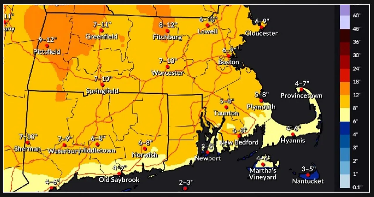
The graphic above combines the snowfall from the current storm with the upcoming weekend storm.
The forecast provides a timeline for the arrival of the new snow.
This afternoon
Snow and freezing rain, potentially combined with sleet, before 2pm, followed by freezing rain between 2pm and 3pm, with a risk of rain after that. The high is around 35. East winds 6 to 10 mph, with gusts up to 20 mph. The chance of precipitation is 100 percent. Total daytime snow and sleet accumulation of 1 to 3 inches is likely.
Tonight
The weather is mostly overcast, with a low of 31 degrees. Southwest winds range from 5 to 9 mph.
Friday
The weather is mostly sunny, with a high around 41. West wind 8-16 mph, with gusts up to 30 mph.
Friday Night
Partly overcast, with a low of around 19. West wind 5-10 mph.
Saturday
The weather is mostly sunny, with a high around 34 degrees. Northwest wind 5 to 7 mph.
Saturday Night
The snowfall mostly occurs after 11 p.m. Snowfall could be substantial at times. The low is expected to be around 24. After midnight, the wind will shift to the east at a speed of about 5 mph. The chance of precipitation is 100 percent. New snow accumulation of 3 to 7 inches is possible.
Sunday
The forecast predicts snow and sleet before 1pm, with a risk of snow from 1pm to 4pm. The high is around 36. The east wind is blowing at 6 to 10 mph, with a shift to the northwest in the afternoon. Winds could gust up to 20 mph. The chance of precipitation is 90%.