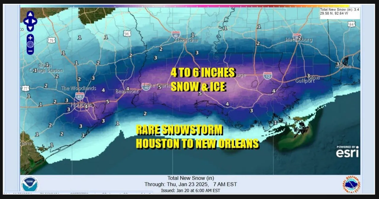
A severe snow and ice storm is expected to hit areas in East Texas, from San Antonio to Corpus Christi, and northeast to major cities like Houston and New Orleans over the next two days. Winter Storm Warnings have been issued by the National Weather Service, even in places where it’s rare to see any snow or ice. Cities and towns along the I-10 corridor in this region lack the necessary resources to clear snow and ice from roadways. With the frigid arctic air covering the Deep South, travel along the I-10 corridor from Houston to New Orleans, and possibly extending to the Florida Panhandle, is likely to be completely disrupted. Some airports, such as Houston, have already announced their plans to shut down in anticipation of this storm system.
Snowfall of 4 to 6 inches is a familiar sight in the northern states, causing inconvenience but minimal disruption. However, in the Deep South and along the Gulf Coast, it is a rare occurrence. Many residents in these areas have never witnessed snow before. The forecast predicts a band of 4 to 6 inches of snow accumulation, stretching from Southeast Texas to Southern Alabama. With temperatures below freezing and in the 20s throughout the event, the snow will cling to everything it touches. The snowfall is expected to begin on Monday night in East Texas and gradually spread to Alabama and Georgia by Tuesday.
An arctic cold front has swept through the Deep South and is currently positioned across the Gulf of Mexico. Strong easterly winds blowing from the Bahamas to Texas will collide with the bitterly cold arctic air that has settled across the South and Southeastern regions of the United States. The clash between these air masses will result in the onset of precipitation in South Texas tonight, which will then spread northward into the frigid air. As a result, snow will begin to develop in Southeast Texas. Moving further south towards San Antonio, Austin, and Corpus Christi, the wintry mix will consist of snow, ice, and freezing rain. On Tuesday, snow and ice will gradually extend eastward across the lower Gulf States, encompassing areas from Louisiana to South Georgia and North Florida. Eventually, the wintry conditions will reach the Southeast US coast, affecting Georgia to the Carolinas on Tuesday night and Wednesday, before moving off to the east. Winter Storm Watches have been issued for these areas, and it is highly likely that the National Weather Service will release additional warnings as this system continues to develop. As a result of this winter weather event, travel throughout the entire South and Southeast US will be exceptionally challenging and, in some cases, even impossible. Numerous disruptions and delays are expected at most airports, and road travel within the Winter Storm Warning zone will be extremely difficult, if not nearly impossible. Therefore, it is strongly recommended to make necessary preparations in advance.


Leave a Reply