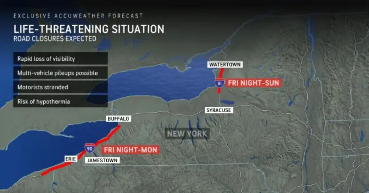
Dangerous, life-threatening conditions will develop in the snow belts downwind of the Great Lakes into early next week, as the lake effect intensifies with whiteouts, rapid accumulation, and plummeting temperatures.
In the days following Thanksgiving, the coldest air of the season will unleash a massive and long-lasting lake-effect snowstorm across Michigan and Wisconsin to Pennsylvania, New York, and Ohio. Meteorologists from AccuWeather warn that the snow in certain regions could be so heavy that it could strand cars and close key routes.
Because the Great Lakes are scorching in comparison to the cold air coming in, towering clouds will form into bands that are only a few miles across.
Within the snow bands, “we expect snowfall rates of 2-3 inches per hour with locally 5 inches per hour, which can close major roads such as interstates 79, 81, 86, and 90, to name a few in the eastern Great Lakes,” AccuWeather Chief Meteorologist Jonathan Porter said.
Sections of major highways, such as 75 and I-196 in Michigan, may also close. In some regions, heavy traffic during the long Thanksgiving weekend may exacerbate road crews’ struggle to keep up with the snow.
For those who have not seen lake-effect snow, blizzard conditions can develop within the snow bands, and feet of snow can accumulate where the bands persist. Outside of the snow bands, just flurries or a clear sky are occasionally present, which can give a false sense of security or significantly varied circumstances from one mile to the next when going on the highway.
“Should a traveler become stranded, the situation can quickly escalate to a life-threatening emergency given the conditions,” Porter pointed out.
Temperatures may drop into the 20s and teens, with AccuWeather RealFeel® temperatures 15–30 degrees lower, taking into account the strong winds that frequently accompany the lake effect. Snow may clog the exhaust systems of certain stranded automobiles, increasing the danger of carbon monoxide poisoning for occupants.
“The conditions and impacts are of great concern during the holiday weekend, as there may be many people traveling through the impacted areas who are not familiar with the intensity and dramatic changes that can occur over short distances with such intense lake-effect snow bands,” according to Porter.
The wind will be primarily from the west-northwest, directing the heaviest snow bands toward some communities but away from others.
Strong gusts can carry snow around, resulting in whiteout conditions and enormous drifts that quickly conceal automobiles and home entrances.
“While there is some risk of a heavy snow band shifting into the city of Buffalo, New York, briefly, most of the time, winds will direct the heaviest snow from the towns south of Buffalo to western New York’s ski country,” according to AccuWeather meteorologist Grady Gilman.
The Buffalo Bills football team plays their home games at Highmark Stadium in Orchard Park, NY. Sunday evening is the team’s next home game, and heavy snow could make it difficult for fans to attend and return home. By the time the game starts, 6 to 12 inches of snow may have accumulated.
We still expect the heaviest snow to fall on Saturday and early Sunday, before the storm bands move south of the stadium. Orchard Park is projected to receive 1-2 feet of snow from the storm, but the strongest bands to the south along I-90 could deliver 2-4 feet by Sunday.
Another snowstorm is expected to hit the eastern Great Lakes region to the east and southeast of Lake Ontario, spanning from Syracuse to Watertown, New York, and including parts of I-81 and I-90. This area, known as the Tug Hill Plateau region, is notable for accumulating feet of lake-effect snow when winds blow from the west or northwest.
AccuWeather forecasts 72 inches (6 feet) of snowfall during the lake-effect event from Thursday night until Tuesday.
While some snow bands can extend hundreds of miles inland from the lake that produces the snow, most of the time little or no snow reaches towns like Indianapolis, Columbus, Ohio, or the I-95 megacities near sea level, including Washington, D.C., Philadelphia, New York City, and Boston.
Lake-effect snow bands, on the other hand, frequently make it to the central and northern Appalachian mountains. These higher heights, particularly west- and northwest-facing slopes, can occasionally receive a few inches of snow. These include northern West Virginia, western Maryland, west-central Pennsylvania, northeastern Pennsylvania, southeastern upstate New York, western Massachusetts, and even Vermont. Especially during winter travel in the mountains, motorists traveling through these places should prepare for changing circumstances.
The same pattern that creates lake-effect snow will also allow fast-moving storms from western Canada, known as Alberta clippers, to pass over parts of the East next week.
In addition to strengthening and shifting snow bands, these storms have the ability to bring snow to areas often ignored by the lake effect, such as those west of Lake Michigan, along I-70 in the Midwest, and along I-95 in the Northeast.
One of these clipper storms has the ability to strengthen swiftly and then slow down when it approaches the Atlantic coast, bringing greater snowfall. Meteorologists at AccuWeather will keep a watchful eye out for these opportunities next week.


Leave a Reply