Severe weather conditions wreaked havoc in the Pacific Northwest on Thursday, while forecasts indicated that heavy rain would make a comeback in several southern and midwestern states. This wave of storms not only disrupted travel plans following the Christmas holiday but also led to the cancellation of numerous flights across the country.
A series of thunderstorms on Thursday afternoon led to ground stops at both Dallas-Fort Worth International Airport and Dallas Love Field. This unfortunate weather event occurred during what AAA had predicted to be the busiest holiday travel season on record. As a result, there were 264 flight cancellations at DFW, making up 22% of all cancellations nationwide, as reported by the flight tracking website FlightAware. Additionally, 550 flights out of DFW experienced delays, accounting for 46% of all delays nationwide.
“We’ve been experiencing a series of delays for our connecting flight from DFW to Tokyo on our second anniversary,” Latoyia Pugh shared with CBS News. “It’s been delayed 12 times, and the communication from the airline has been quite lacking.”
Texas Governor Greg Abbott took action to ensure the state’s readiness for the impending weather by activating the emergency response plan on Thursday afternoon.
Texas Governor Greg Abbott expressed his commitment to ensuring the safety of residents and visitors in the face of severe weather threats. In a statement, he emphasized the state’s preparedness to deploy all necessary resources to assist local officials in their response efforts. As the holiday season comes to a close and people begin to travel, Governor Abbott stressed the importance of regularly monitoring road conditions, creating emergency plans, and following the guidance provided by state and local authorities.
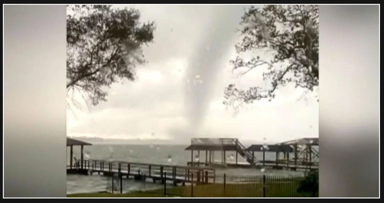
In the evening of Thursday, a suspected tornado reportedly touched down near El Campo, Texas, which is approximately 80 miles southwest of Houston. According to CBS News senior national weather correspondent Rob Marciano, the most powerful storms were occurring in an area spanning from Shreveport, Louisiana, to Beaumont, Texas.
The National Weather Service in Fort Worth had previously issued several alerts and notifications for flash floods, dense fog, tornadoes, and thunderstorms across various areas of the region on Thursday morning. However, all the tornado watches and warnings were subsequently canceled by Thursday night.
Oregon and Washington are forecasted to experience moderate to heavy rainfall and a few thunderstorms on Thursday. The National Weather Service advisory warns of potential flooding in areas where the rain falls rapidly, with up to 3 inches of rainfall expected. Additionally, mountain snow, high winds, and dangerous surf conditions are anticipated in the region.
Almost 60,000 customers in Washington and Oregon were left without power at one point on Thursday morning, as reported by the outage tracker FindEnergy.com. However, by Thursday night, the number of affected customers had decreased to around 14,600.
The West Coast is currently being affected by an atmospheric river, which has resulted in a series of storms. Meteorologists predict that the initial round of storms in the Northwest will move inland by Thursday afternoon, providing a brief break before another round of severe weather hits the same areas on Thursday night. By Friday morning, this upcoming spell is expected to bring an additional inch or two of rainfall.
High wind warnings were also issued for coastal areas of Oregon and Washington, with forecasters in Medford, Oregon, cautioning that strong winds could cause damage to trees and power lines.
The National Weather Service in Seattle issued similar warnings during the night from Wednesday to Thursday, cautioning that wind gusts in coastal areas could reach a maximum of 60 mph, while gusts around the Puget Sound could reach up to 55 mph. Meteorologists in Portland reported a staggering wind gust of 92 mph at Beacon Rock, Washington, located approximately 35 miles east of Portland, in the early hours of Thursday morning.
Widespread Wind Advisories & High Wind Warnings are in effect tonight through Thursday morning. Gusts are forecast to peak around 60 MPH for the coast & Admiralty Inlet northward. Gusts of 45 to 55 MPH are expected for Puget Sound. Localized stronger wind gusts possible. #wawx https://t.co/ZYVosC6Wwh pic.twitter.com/tgZLzRQoGw
— NWS Seattle (@NWSSeattle) December 26, 2024
The West Coast has recently experienced a series of dangerous weather events, with the Pacific Northwest being hit by the latest storms. One unfortunate incident occurred in Sunset State Beach, Santa Cruz, where a person lost their life after being trapped under debris caused by a large wave. The authorities believe that the wave led to the debris piling up on top of the victim. Additionally, two individuals had to be rescued when a section of the Santa Cruz Wharf collapsed.
Thick fog blanketed parts of the Midwest on Thursday. In Kansas City, meteorologists anticipated that fog and light rain would continue throughout the day, with particularly low visibility in certain areas. Central and eastern Kansas, as well as central Missouri, were expected to experience visibility of less than a quarter of a mile in some places during the morning. Although the fog was predicted to diminish to some extent in the afternoon, it was likely to persist to a certain degree.
The outlooks for areas further north in Illinois were quite similar.
“Areas of dense fog will remain over parts of northern Illinois into this afternoon,” the National Weather Service in Chicago said in a mid-morning advisory Thursday. “Expect low visibilities and slowed driving out on the roads until conditions improve.”
Areas of dense fog will remain over parts of northern Illinois into this afternoon. Expect low visibilities and slowed driving out on the roads until conditions improve. Take extra caution if you encounter fog while driving today! #ILwx #INwx pic.twitter.com/c1zp4XwoI4
— NWS Chicago (@NWSChicago) December 26, 2024







Leave a Reply