
The storm train’s lead car will slowly bring rain to western Washington and Oregon throughout Saturday. It will then pick up speed and spread precipitation to the northern Rockies by Sunday.
AccuWeather Lead Long-Range Expert Paul Pastelok forecasts that storms will sweep into the Northwest region every few days from the Pacific Ocean.
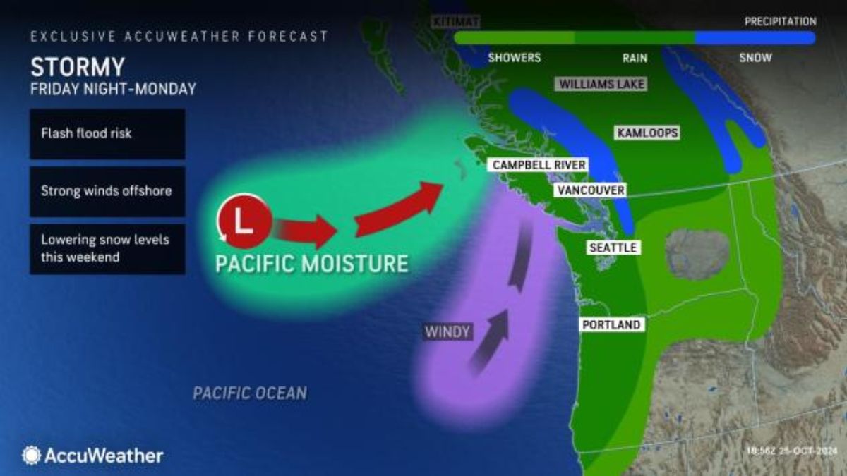
The first car of the storm train will bring rain to western Washington and Oregon starting from Friday night and continuing through Saturday. As it gains momentum, the precipitation will spread into the northern Rockies by Sunday.
This weekend, the northwestern coastline of Oregon and Washington is expected to experience the heaviest rainfall, with the potential for 1-3 inches of rain.
AccuWeather Meteorologist Alyssa Glenny warned that localized flooding may occur, particularly in low-lying areas with poor drainage.
The upcoming storm is set to deliver the most substantial rainfall of the season for areas along the Interstate 5 corridor, spanning from Portland, Oregon to Seattle. Meteorologists predict that this single event could bring a couple of inches of rainfall by early next week.
According to Glenny, locations in northwestern Washington, including Olympia and Seattle, have received only about 35% of their usual monthly rainfall for October. Therefore, this storm could provide a much-needed boost of moisture before the month comes to a close.
In October, the Pacific Northwest experiences a notable increase in average precipitation compared to the drier summer months.
As the storm moves inland, expect the winds to pick up, reaching gusts of 30 to 50 mph along the coast and over the ridgetops. At lower elevations, there will be a noticeable breeze. These blustery conditions could potentially increase the risk of fires and lead to unpredictable wildfire behavior before any rainfall arrives.
According to Pastelok, the fires in Oregon and Idaho will gradually be brought under control in this pattern.
A blast of cold air following the storm will result in a drop in snow levels in the Cascades and northern Rockies from Sunday to early next week. This could make travel along I-90’s Snoqualmie Pass hazardous, as temperatures plummet close to freezing and snowfall is anticipated on Sunday night.
According to Glenny, it is important to be cautious when traveling on less-traveled secondary roads as they may have a higher risk of slick spots.
Cold air is set to sweep across the interior West by next week, specifically on Monday and Tuesday. During this time, there will be accumulating snow in the high terrain of Utah, Wyoming, and Colorado.
According to Pastelok, ski areas will begin constructing their snowpack.
The residents of the Desert Southwest, who have been enduring unusually high temperatures reminiscent of summer, can finally look forward to some relief. By Tuesday, cooler air is expected to sweep in, bringing respite from the sweltering conditions. In Phoenix, where temperatures have been consistently 8 degrees above the historical average this month, highs in the 70s are forecasted for next Tuesday and Wednesday. Similarly, after several days in the 80s, Las Vegas will cool down into the comfortable 60s.
“This will be a cooler pattern compared to early and mid-October,” Pastelok said.
We expect another storm to hit the Northwest in the middle and late next week, around Halloween. This storm may deliver extra snow to the Cascades and northern Rockies.
According to AccuWeather’s long-range experts, the storm train is expected to continue through the first weekend of November.